
Somba Opu topographic map
Interactive map
Click on the map to display elevation.
About this map
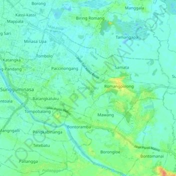
Name: Somba Opu topographic map, elevation, terrain.
Location: Somba Opu, Gowa, Sulawesi du Sud, Indonésie (-5.23228 119.43959 -5.17753 119.52132)
Average elevation: 10 m
Minimum elevation: -5 m
Maximum elevation: 42 m
Other topographic maps
Click on a map to view its topography, its elevation and its terrain.
Buntu Lempo
Buntu Lempo, Sulawesi du Sud, Indonésie
Average elevation: 425 m
Pai
Indonésie > Sulawesi du Sud > Makassar
Pai, Biringkanaya, Makassar, Sulawesi du Sud, Indonésie
Average elevation: 15 m
Lajangiru
Indonésie > Sulawesi du Sud > Makassar
Lajangiru, Ujung Pandang, Makassar, Sulawesi du Sud, Indonésie
Average elevation: 7 m
Buttu Matopo
Buttu Matopo, Sulawesi du Sud, Indonésie
Average elevation: 1,122 m