
Make a donation
Gear up for your next adventure:
As an Amazon Associate, this site earns from qualifying purchases at no extra cost to you.
County Kilkenny topographic map
Click on the map to display elevation.
Make a donation
Gear up for your next adventure:
As an Amazon Associate, this site earns from qualifying purchases at no extra cost to you.
County Kilkenny
The River Nore flows through the county and the River Suir forms the border with County Waterford. Brandon Hill is the highest point with an elevation of 515 m (1,690 ft). Most of the county has a hilly surface of moderate elevation with uplands in the north-east, the north-west and the South of the county; the middle is lower by comparison.[7]
Make a donation
Gear up for your next adventure:
As an Amazon Associate, this site earns from qualifying purchases at no extra cost to you.
About this map
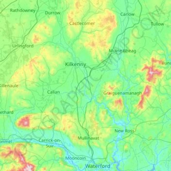
Name: County Kilkenny topographic map, elevation, terrain.
Location: County Kilkenny, Leinster, Ireland (52.24287 -7.67400 52.89394 -6.91456)
Average elevation: 120 m
Minimum elevation: -4 m
Maximum elevation: 784 m
Make a donation
Gear up for your next adventure:
As an Amazon Associate, this site earns from qualifying purchases at no extra cost to you.
Other topographic maps
Click on a map to view its topography, its elevation and its terrain.
Make a donation
Gear up for your next adventure:
As an Amazon Associate, this site earns from qualifying purchases at no extra cost to you.
Make a donation
Gear up for your next adventure:
As an Amazon Associate, this site earns from qualifying purchases at no extra cost to you.
Make a donation
Gear up for your next adventure:
As an Amazon Associate, this site earns from qualifying purchases at no extra cost to you.
Limerick
Limerick's climate is classified as temperate oceanic (Köppen Cfb). Met Éireann maintains a climatological weather station at Shannon Airport, 20 kilometres west of the city in County Clare. Shannon Airport records an average of 977 millimetres of precipitation annually, most of which is rain. Limerick has a…
Average elevation: 10 m
Make a donation
Gear up for your next adventure:
As an Amazon Associate, this site earns from qualifying purchases at no extra cost to you.
Make a donation
Gear up for your next adventure:
As an Amazon Associate, this site earns from qualifying purchases at no extra cost to you.
Make a donation
Gear up for your next adventure:
As an Amazon Associate, this site earns from qualifying purchases at no extra cost to you.