
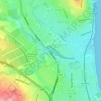
Loughlinstown River, North topographic map
Interactive map
Click on the map to display elevation.
About this map
Name: Loughlinstown River, North topographic map, elevation, terrain.
Average elevation: 36 m
Minimum elevation: -1 m
Maximum elevation: 117 m
Other topographic maps
Click on a map to view its topography, its elevation and its terrain.
Dún Laoghaire-Rathdown
Dún Laoghaire-Rathdown, County Dublin, Leinster, Ireland
Average elevation: 139 m
Tallaght
Ireland > County Dublin > Tallaght
Tallaght, South Dublin, County Dublin, Leinster, D24 T99C, Ireland
Average elevation: 121 m
14
Ireland > County Dublin > Blackrock
14, The Stables, Mount Merrion, Mountmerrion or Callary, Stillorgan-Mount Merrion ED, Blackrock, Dún Laoghaire-Rathdown, County Dublin, Leinster, A94 EK75, Ireland
Average elevation: 48 m
Dún Laoghaire
Dún Laoghaire, Dún Laoghaire-Rathdown, County Dublin, Leinster, A96 T860, Ireland
Average elevation: 21 m
Blackrock
Ireland > County Dublin > Blackrock
Blackrock, Dún Laoghaire-Rathdown, County Dublin, Leinster, A94 RF20, Ireland
Average elevation: 30 m