Geolocate

Dundrum topographic map

Click on the map to display elevation.

About this map

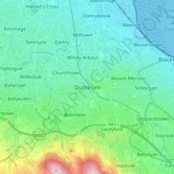
Name: Dundrum topographic map, elevation, terrain.

Location: Dundrum, Dún Laoghaire-Rathdown, County Dublin, Leinster, D14 V9R3, Ireland (53.24915 -6.28338 53.32915 -6.20338)

Average elevation: 79 m

Minimum elevation: -1 m

Maximum elevation: 414 m

Other topographic maps

Click on a map to view its topography, its elevation and its terrain.

Swords

Ireland > County Dublin

At the northern end of the street stands Swords Castle, 200m northeast of the ecclesiastical site, which was built in the early 13th century. A short distance north of the castle is the elevation known as Spittal Hill, where a hospital once stood.

Average elevation: 25 m

Dún Laoghaire-Rathdown

Ireland > County Dublin

Average elevation: 139 m

Irishtown

Ireland > County Dublin > Dublin

Average elevation: 5 m

Gear up for your next adventure:

🛶Kayak Accessories - Essential gear for safe and fun kayaking adventures
🧤Thermal Hiking Gloves - Grip-enhanced gloves for cold-weather altitude trekking
🧴First Aid Kit - Essential first aid supplies for outdoor emergencies
🥫Freeze-Dried Meals - Lightweight, high-calorie nutrition for multi-day treks
🥾Mountain Hiking Shoes - Shoes with superior grip for mountainous terrain

As an Amazon Associate, this site earns from qualifying purchases at no extra cost to you.