Geolocate

Gatton topographic map

Click on the map to display elevation.

Gatton

The area has a humid subtropical climate, with hot, humid summers and mild, sunny winters, albeit with cool nights. Heavy summer rain and warm conditions have provided ideal conditions for the areas agricultural productivity, although droughts and heatwaves can be problematic at times. Temperatures in Gatton are among the warmest in south-east Queensland in summer due to its position away from the coast but at low elevation in the Brisbane Valley.

Wikipedia (CC-BY-SA 3.0)

About this map

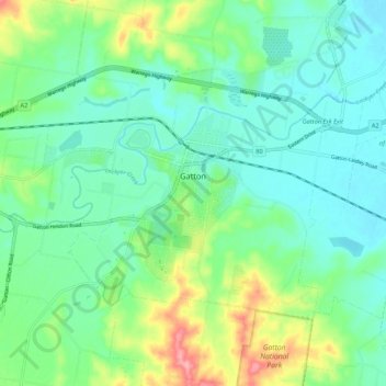
Name: Gatton topographic map, elevation, terrain.

Location: Gatton, Lockyer Valley Regional, Queensland, Australia (-27.59661 152.21943 -27.53495 152.32628)

Average elevation: 118 m

Minimum elevation: 86 m

Maximum elevation: 203 m

Other topographic maps

Click on a map to view its topography, its elevation and its terrain.

Silver Valley

Australia > Queensland

The locality is mountainous, rising from an elevation of 650 metres (2,130 ft) in Bulldog Gully in the south of the locality through to numerous peaks in the locality (from north to south).

Average elevation: 676 m

Bundaberg

Australia > Queensland > Bundaberg Region

Average elevation: 18 m

Banff park

Australia > Queensland > Gold Coast City

Average elevation: 11 m

Hervey Bay

Australia > Queensland > Hervey Bay

Average elevation: 6 m

Poona

Australia > Queensland

Average elevation: 5 m

Great Wall

Australia > Queensland

Average elevation: 354 m

Allan Creek

Australia > Queensland

Average elevation: 108 m

Digby Island

Australia > Queensland

Average elevation: 4 m

Grange Heights

Australia > Queensland > Brisbane City

Average elevation: 34 m

Great Dividing Range

Australia > Queensland

Average elevation: 939 m

Tudu Island

Australia > Queensland

Average elevation: 0 m

Sunshine Coast

Australia > Queensland > Sunshine Coast Regional

The Sunshine Coast in Queensland, Australia, showcases a diverse topography that harmoniously blends coastal plains with rugged hinterlands. Along its eastern edge, the region features expansive sandy beaches and coastal dunes that transition smoothly into fertile lowlands. Inland, the terrain becomes more…

Average elevation: 109 m

Isis River

Australia > Queensland > Bundaberg Region > Buxton

Average elevation: 12 m

Aratula

Australia > Queensland > Aratula

Average elevation: 118 m

Cracow

Australia > Queensland > Cracow

Average elevation: 360 m

Mica Creek

Australia > Queensland > Mount Isa

Average elevation: 403 m

Gillies

Australia > Queensland > Tarzali

Average elevation: 757 m

Mount Cotton

Australia > Queensland

Average elevation: 105 m

Sidney Island

Australia > Queensland

Average elevation: 0 m

Gear up for your next adventure:

🧢Hiking Sun Hat - Wide-brimmed protection for exposed mountain ridges
🕶️Polarized Sunglasses - Protect your eyes with durable polarized lenses
🛶Kayak Accessories - Essential gear for safe and fun kayaking adventures
📷Outdoor Action Camera - Capture high-elevation views and rugged adventures
🧰Multitool Knife - Compact and versatile tool for outdoor use

As an Amazon Associate, this site earns from qualifying purchases at no extra cost to you.