Geolocate

Sinagra topographic map

Click on the map to display elevation.

About this map
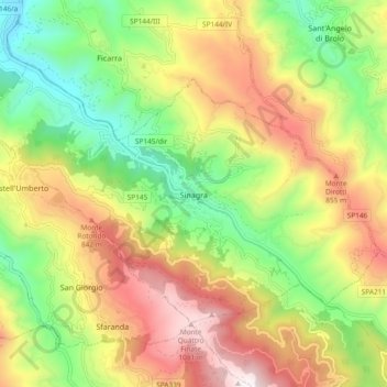
Name: Sinagra topographic map, elevation, terrain.

Location: Sinagra, Messina, Sicily, 98069, Italy (38.05860 14.80089 38.10801 14.89437)

Average elevation: 547 m

Minimum elevation: 60 m

Maximum elevation: 1,140 m

Other topographic maps

Click on a map to view its topography, its elevation and its terrain.
Stromboli

Italy > Sicily > Messina > Lipari

Average elevation: 372 m

Gear up for your next adventure:

🧦Crew Hiking Socks - Comfortable socks for long-distance hikes
💡Solar Camping Lamp - Eco-friendly lighting for campsites
🧥Waterproof Pants - Keep dry during rainy hiking conditions
🥾Waterproof Hiking Shoes - Durable shoes for wet and rugged trails
🔋Emergency Crank Radio - Weather alerts and power without needing batteries

As an Amazon Associate, this site earns from qualifying purchases at no extra cost to you.