Geolocate

Jirania topographic map

Click on the map to display elevation.

About this map

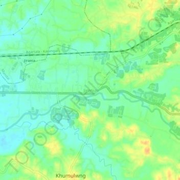
Name: Jirania topographic map, elevation, terrain.

Location: Jirania, West Tripura, Tripura, 799035, India (23.79921 91.42568 23.83921 91.46568)

Average elevation: 40 m

Minimum elevation: 27 m

Maximum elevation: 56 m

Other topographic maps

Click on a map to view its topography, its elevation and its terrain.

Mandai

India > Tripura > Jirania

Average elevation: 64 m

Jirania

India > Tripura > Jirania

Average elevation: 47 m

Gear up for your next adventure:

💧Hydration Pack - Hands-free hydration system for long hikes
🔭Compact Monocular - One-handed bird watching and trail spotting
🌬️Windproof Camp Stove - Efficient cooking even on exposed mountain peaks
🗺️Topographic Maps - Detailed maps to explore trails, mountains, and wilderness areas
🧴Insect Repellent - Protect yourself from bugs during outdoor adventures

As an Amazon Associate, this site earns from qualifying purchases at no extra cost to you.