Geolocate

Jirania topographic map

Click on the map to display elevation.

About this map

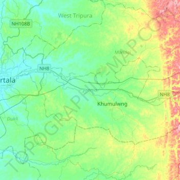
Name: Jirania topographic map, elevation, terrain.

Location: Jirania, West Tripura, Tripura, India (23.74646 91.30706 23.88929 91.56360)

Average elevation: 47 m

Minimum elevation: 11 m

Maximum elevation: 145 m

Other topographic maps

Click on a map to view its topography, its elevation and its terrain.

Jirania

India > Tripura > Jirania

Average elevation: 40 m

Gear up for your next adventure:

🧰Emergency Multi-Tool - Compact multi-tool for outdoor survival
🧣Evaporative Cooling Towel - Beat the heat during intense summer climbs
🧭GPS Outdoor Watch - Smart watch for navigation and fitness tracking in nature
🧤Thermal Hiking Gloves - Grip-enhanced gloves for cold-weather altitude trekking
🪜Heavy Duty Carabiners - Multi-use clips for securing gear to your backpack

As an Amazon Associate, this site earns from qualifying purchases at no extra cost to you.