Geolocate

Evant topographic map

Click on the map to display elevation.

About this map

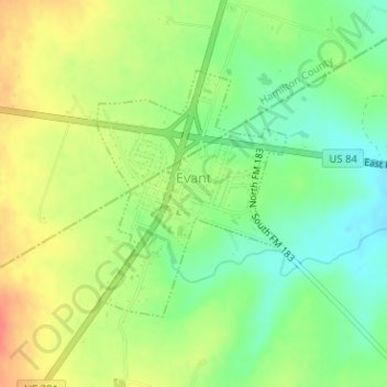
Name: Evant topographic map, elevation, terrain.

Location: Evant, Coryell County, Texas, United States (31.46747 -98.15825 31.48466 -98.14270)

Average elevation: 382 m

Minimum elevation: 357 m

Maximum elevation: 411 m

Other topographic maps

Click on a map to view its topography, its elevation and its terrain.

Pidcoke

United States > Texas > Coryell County

Average elevation: 264 m

King Mountain

United States > Texas > Coryell County

Average elevation: 240 m

Purmela

United States > Texas > Coryell County

Average elevation: 321 m

Cold Springs

United States > Texas > Coryell County

Average elevation: 250 m

Gear up for your next adventure:

🧥Packable Rain Jacket - Breathable waterproof layer for unpredictable weather
🥾All-Terrain Hiking Boots - Versatile boots for varied hiking conditions
🕶️Polarized Sunglasses - Reduces glare from snow and water at high elevations
👟Trail Running Shoes - Agile footwear for fast-paced topographic exploration
🧭GPS Outdoor Watch - Smart watch for navigation and fitness tracking in nature

As an Amazon Associate, this site earns from qualifying purchases at no extra cost to you.