
Wentworth-Nord topographic map
Interactive map
Click on the map to display elevation.
About this map
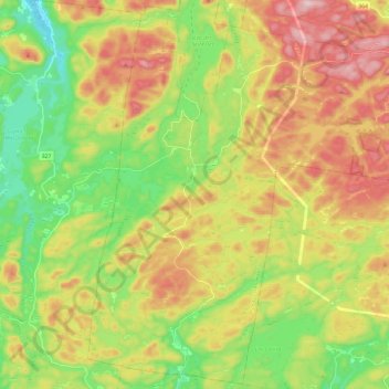
Name: Wentworth-Nord topographic map, elevation, terrain.
Average elevation: 330 m
Minimum elevation: 183 m
Maximum elevation: 517 m
Les Pays-d'en-Haut trails, hiking, mountain biking, running and outdoor activities
Other topographic maps
Click on a map to view its topography, its elevation and its terrain.
Saint-Michel-de-Wentworth
Canada > Quebec > Les Pays-d'en-Haut > Wentworth-Nord
Average elevation: 320 m
Lac Saint-Louis
Canada > Quebec > Les Pays-d'en-Haut > Sainte-Marguerite-du-Lac-Masson
Average elevation: 443 m
Lac Marier
Canada > Quebec > Les Pays-d'en-Haut > Sainte-Marguerite-du-Lac-Masson
Average elevation: 377 m
Mont Edward
Canada > Quebec > Les Pays-d'en-Haut > Sainte-Marguerite-du-Lac-Masson
Average elevation: 431 m