Geolocate

Dollingstown topographic map

Click on the map to display elevation.

About this map

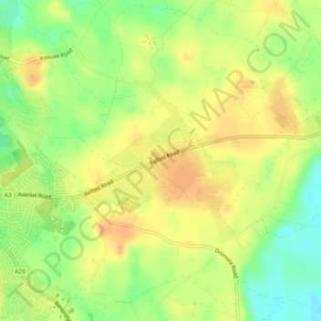
Name: Dollingstown topographic map, elevation, terrain.

Location: Dollingstown, County Down, Northern Ireland, United Kingdom (54.45500 -6.30634 54.46866 -6.28332)

Average elevation: 56 m

Minimum elevation: 35 m

Maximum elevation: 69 m

Other topographic maps

Click on a map to view its topography, its elevation and its terrain.

Bangor

United Kingdom > Northern Ireland > County Down

Average elevation: 40 m

Drumbo

United Kingdom > Northern Ireland > County Down

Average elevation: 94 m

Ben Crom

United Kingdom > Northern Ireland > County Down

Average elevation: 384 m

Annahilt

United Kingdom > Northern Ireland > County Down

Average elevation: 104 m

Newry

United Kingdom > Northern Ireland > County Down

Average elevation: 129 m

Bangor

United Kingdom > Northern Ireland > County Down

Average elevation: 40 m

Attical

United Kingdom > Northern Ireland > County Down

Average elevation: 155 m

Newry

United Kingdom > Northern Ireland > County Down

Average elevation: 129 m

Moira

United Kingdom > Northern Ireland > County Down

Average elevation: 59 m

Balloo

United Kingdom > Northern Ireland > County Down

Average elevation: 39 m

Dromara

United Kingdom > Northern Ireland > County Down

Average elevation: 149 m

Ballela

United Kingdom > Northern Ireland > County Down

Average elevation: 136 m

Dromore

United Kingdom > Northern Ireland > County Down

Average elevation: 106 m

Bleary

United Kingdom > Northern Ireland > County Down > Bleary

Average elevation: 64 m

Hilltown

United Kingdom > Northern Ireland > County Down

Average elevation: 136 m

Kilkeel

United Kingdom > Northern Ireland > County Down

Average elevation: 35 m

Newry

United Kingdom > Northern Ireland > County Down

Average elevation: 73 m

Scarva

United Kingdom > Northern Ireland > County Down

Average elevation: 56 m

Gilford

United Kingdom > Northern Ireland > County Down

Average elevation: 43 m

Ardglass

United Kingdom > Northern Ireland > County Down

Average elevation: 217 m

Kilcoo

United Kingdom > Northern Ireland > County Down

Average elevation: 156 m

Newry

United Kingdom > Northern Ireland > County Down

Average elevation: 73 m

Newry

United Kingdom > Northern Ireland > County Down

Average elevation: 129 m

Gear up for your next adventure:

🌬️Windproof Camp Stove - Efficient cooking even on exposed mountain peaks
💧Hydration Pack - Hands-free hydration system for long hikes
Camping Groundsheet - Protect your tent from moisture and dirt
🛁Quick-Dry Microfiber Towel - Space-saving towel that dries rapidly on the move
💧Collapsible Water Bottle - Space-saving water bottle for outdoor activities

As an Amazon Associate, this site earns from qualifying purchases at no extra cost to you.