
Clipston topographic map
Click on the map to display elevation.
Clipston
Clipston stands on the northernmost edge of the Wolds in Nottinghamshire. The area enjoys, from an elevation of about 79 m/259 ft, panoramic views of the Trent valley and the East and South side of the city of Nottingham, some 50 m/164 ft lower. Nearby to the west is Hoe Hill, with a horseshoe-shaped wood.
About this map
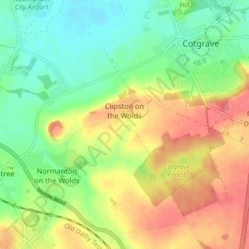
Name: Clipston topographic map, elevation, terrain.
Average elevation: 59 m
Minimum elevation: 27 m
Maximum elevation: 97 m
Other topographic maps
Click on a map to view its topography, its elevation and its terrain.
Stanton on the Wolds
United Kingdom > England > Nottinghamshire > Rushcliffe > Stanton on the Wolds
Average elevation: 78 m
Bassingfield
United Kingdom > England > Nottinghamshire > Rushcliffe > Holme Pierrepont > Bassingfield
Average elevation: 28 m
Archers Lake
United Kingdom > England > Nottinghamshire > Rushcliffe > Bingham
Average elevation: 28 m