
Kaiping topographic map
Click on the map to display elevation.
About this map
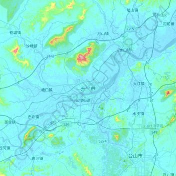
Name: Kaiping topographic map, elevation, terrain.
Location: Kaiping, Jiangmen, Guangdong Province, 529300, China (22.21999 112.53324 22.53999 112.85324)
Average elevation: 23 m
Minimum elevation: -9 m
Maximum elevation: 426 m
Other topographic maps
Click on a map to view its topography, its elevation and its terrain.
Nanshan District
At 587 meters (1,926 ft) tall, Yangtaishan has the highest elevation in the district, with Tanglangshan being the second at 430 meters (1,411 ft), and Nanshan, third, at 336 meters (1,102 ft). The district has a total coastline of 55.18 kilometers (34.29 mi).
Average elevation: 35 m
Fairy Lake
China > Guangdong Province > Luohu District > Liantang Sub-district
Average elevation: 111 m
Jiangmen
A significant amount of historical heritage survives from the period of mass emigration prior to World War II. The most significant are the fortified multi-story towers found mainly in Kaiping. These are known as "Gold Mountain Towers" or diaolou. A number of natural hotspring resorts has been developed…
Average elevation: 31 m