Geolocate

Fengkai County topographic map

Click on the map to display elevation.

About this map

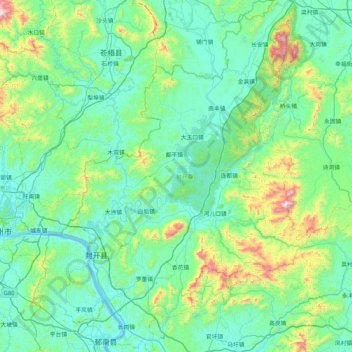
Name: Fengkai County topographic map, elevation, terrain.

Location: Fengkai County, Zhaoqing City, Guangdong Province, China (23.21393 111.35738 23.98194 112.02819)

Average elevation: 190 m

Minimum elevation: 0 m

Maximum elevation: 1,213 m

Other topographic maps

Click on a map to view its topography, its elevation and its terrain.

Du Village

China > Guangdong Province > Zhaoqing City

Average elevation: 96 m

Gear up for your next adventure:

🛁Quick-Dry Microfiber Towel - Space-saving towel that dries rapidly on the move
Camping Coffee Maker - Brew fresh coffee anywhere on the topographic map
🔋Emergency Crank Radio - Weather alerts and power without needing batteries
🛌Down Sleeping Bag - Superior warmth-to-weight ratio for cold nights
🧤Insulated Winter Gloves - Heavy-duty protection for sub-zero Canadian adventures

As an Amazon Associate, this site earns from qualifying purchases at no extra cost to you.