
Yell County topographic map
Click on the map to display elevation.
Yell County
Upon settlement, Yell County's varied topography created a stratified society, splitting settlers between the more fertile and productive farms of the "lowlands" and the subsistence farming of the steep and less-productive mountain soil of the "uplands". A planter class emerged in the lowlands, and as Dardanelle evolved into a cohesive community, the large landowners moved to town and managed their landholdings from stately homes, similar to the model seen in the Arkansas Delta and the Mississippi Delta. This left the lowlands inhabited largely by poor sharecroppers and tenant farmers, who largely shared economic fortunes with the small farms in the uplands, shifting the "upland/lowland" split to a "town-country" divide based largely on economics.
About this map
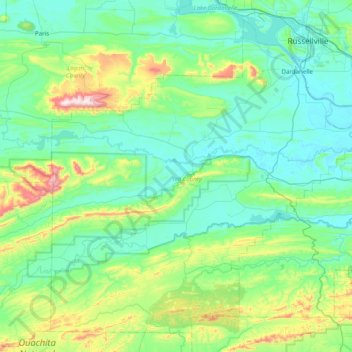
Name: Yell County topographic map, elevation, terrain.
Location: Yell County, Arkansas, United States (34.74329 -93.71002 35.31753 -92.92204)
Average elevation: 218 m
Minimum elevation: 88 m
Maximum elevation: 833 m
Other topographic maps
Click on a map to view its topography, its elevation and its terrain.
Mount Magazine State Park
United States > Arkansas > Logan County
There also exist many opportunities for ATV riding, backpacking, hang gliding, mountain biking, rappelling, and rock climbing within the park. The park hosts the annual Mount Magazine International Butterfly Festival, and is a haven for many rare species of butterflies in Arkansas due to the special blend of…
Average elevation: 667 m
Thorn Crown Chapel
United States > Arkansas > Carroll County > Eureka Springs
Average elevation: 390 m
Sweetwater Estates
United States > Arkansas > Lonoke County > Ward > Sweetwater Estates
Average elevation: 85 m
Willow Beach Lake Dam
United States > Arkansas > Pulaski County > North Little Rock
Average elevation: 73 m