Geolocate

Cooper Point topographic map

Click on the map to display elevation.

About this map

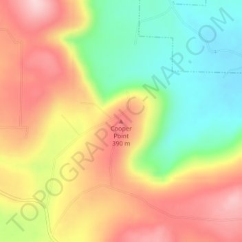
Name: Cooper Point topographic map, elevation, terrain.

Location: Cooper Point, Stone County, Arkansas, 72560, United States (35.83364 -92.10270 35.83374 -92.10260)

Average elevation: 303 m

Minimum elevation: 184 m

Maximum elevation: 420 m

Other topographic maps

Click on a map to view its topography, its elevation and its terrain.

Mountain View

United States > Arkansas > Stone County

Average elevation: 248 m

Stone County

United States > Arkansas > Stone County

Average elevation: 268 m

Gear up for your next adventure:

🌬️Windproof Camp Stove - Efficient cooking even on exposed mountain peaks
🌡️Emergency Mylar Blankets - Compact thermal protection for unexpected nights outdoors
🧊Insulated Water Bottle - Keeps drinks cold in summer and prevents freezing in winter
🧴Insect Repellent - Protect yourself from bugs during outdoor adventures
🦶Hiking Shoe Insoles - Added support for high arches and long days on feet

As an Amazon Associate, this site earns from qualifying purchases at no extra cost to you.