
Arkadelphia topographic map
Click on the map to display elevation.
About this map
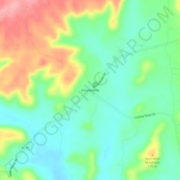
Name: Arkadelphia topographic map, elevation, terrain.
Location: Arkadelphia, Cullman County, Alabama, United States (33.88510 -86.98250 33.92510 -86.94250)
Average elevation: 129 m
Minimum elevation: 83 m
Maximum elevation: 211 m
Other topographic maps
Click on a map to view its topography, its elevation and its terrain.
Holly Pond
United States > Alabama > Cullman County
Holly Pond is located in eastern Cullman County at 34°10′29″N 86°37′1″W / 34.17472°N 86.61694°W / 34.17472; -86.61694 (34.174657, -86.617004). The town is concentrated around the intersection of U.S. Route 278 and State Route 91. The elevation at the center of town is approximately 870…
Average elevation: 249 m