Geolocate

Good Hope topographic map

Click on the map to display elevation.

About this map

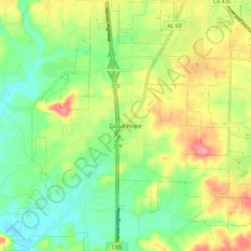
Name: Good Hope topographic map, elevation, terrain.

Location: Good Hope, Cullman County, Alabama, United States (34.08365 -86.90160 34.14829 -86.82723)

Average elevation: 210 m

Minimum elevation: 171 m

Maximum elevation: 266 m

Other topographic maps

Click on a map to view its topography, its elevation and its terrain.

Arkadelphia

United States > Alabama > Cullman County

Average elevation: 129 m

Duck River

United States > Alabama > Cullman County

Average elevation: 235 m

Crane Hill

United States > Alabama > Cullman County

Average elevation: 215 m

Trimble

United States > Alabama > Cullman County

Average elevation: 185 m

Hanceville

United States > Alabama > Cullman County > Hanceville

Average elevation: 178 m

Gear up for your next adventure:

🦯Trekking Poles - Reduced impact on joints for steep topographic climbs
🦶Hiking Shoe Insoles - Added support for high arches and long days on feet
🧭GPS Outdoor Watch - Smart watch for navigation and fitness tracking in nature
🥾Hiking Shorts - Breathable shorts suitable for summer hikes
🔦LED Headlamp - Hands-free lighting for early morning starts or late finishes

As an Amazon Associate, this site earns from qualifying purchases at no extra cost to you.