Geolocate

Hanceville topographic map

Click on the map to display elevation.

About this map

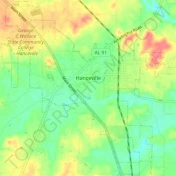
Name: Hanceville topographic map, elevation, terrain.

Location: Hanceville, Cullman County, Alabama, United States (34.03533 -86.79550 34.08684 -86.73030)

Average elevation: 177 m

Minimum elevation: 149 m

Maximum elevation: 215 m

Gear up for your next adventure:

🥾Trekking Boots - Durable boots for long-distance trekking
🛌Down Sleeping Bag - Superior warmth-to-weight ratio for cold nights
🥾Hiking Boots - Sturdy boots providing ankle support and traction on rugged trails
👖Convertible Hiking Pants - Zip-off legs to adapt to changing weather conditions
🧭GPS Tracker - Track your location in remote areas safely

As an Amazon Associate, this site earns from qualifying purchases at no extra cost to you.