
Make a donation
Gear up for your next adventure:
As an Amazon Associate, this site earns from qualifying purchases at no extra cost to you.
Nordkampen topographic map
Click on the map to display elevation.
Make a donation
Gear up for your next adventure:
As an Amazon Associate, this site earns from qualifying purchases at no extra cost to you.
Nordkampen
Der Ort wurde zusammen mit Südkampen erstmals 1255 in der Urkunde Nr. 43 des Walsroder Klosters erwähnt. Ein Feld bzw. Ackerland (lat. campus) führte zur Namensgebung dieser Dörfer. Die Himmelsrichtungen Nord bzw. Süd veranschaulichen die topografische Trennung. Früher gab es auch die Bezeichnungen „Swattencampen“ für Nordkampen und „Wittencampen“ für Südkampen.
Make a donation
Gear up for your next adventure:
As an Amazon Associate, this site earns from qualifying purchases at no extra cost to you.
About this map
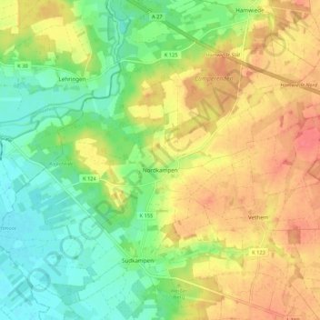
Name: Nordkampen topographic map, elevation, terrain.
Location: Nordkampen, Walsrode, Heidekreis, Niedersachsen, Deutschland (52.84537 9.37540 52.88700 9.48192)
Average elevation: 43 m
Minimum elevation: 15 m
Maximum elevation: 72 m
Make a donation
Gear up for your next adventure:
As an Amazon Associate, this site earns from qualifying purchases at no extra cost to you.
Other topographic maps
Click on a map to view its topography, its elevation and its terrain.
Make a donation
Gear up for your next adventure:
As an Amazon Associate, this site earns from qualifying purchases at no extra cost to you.
Make a donation
Gear up for your next adventure:
As an Amazon Associate, this site earns from qualifying purchases at no extra cost to you.