
Make a donation
Gear up for your next adventure:
As an Amazon Associate, this site earns from qualifying purchases at no extra cost to you.
Düshorn topographic map
Click on the map to display elevation.
Make a donation
Gear up for your next adventure:
As an Amazon Associate, this site earns from qualifying purchases at no extra cost to you.
Düshorn
In einer Beschreibung des ehemaligen Heimatpflegers des Kreises Fallingbostel, Hans Stuhlmacher (Schneeheide) wird der Ortsname so gedeutet: Düshorn wurde im Jahre 1227 erstmals urkundlich erwähnt, und zwar als Dushorne. In dem alten Ortsnamen steht „Dus“ für „düster“, „horn“ für Anhöhe, vielleicht auch für Tweshorn.
Make a donation
Gear up for your next adventure:
As an Amazon Associate, this site earns from qualifying purchases at no extra cost to you.
About this map
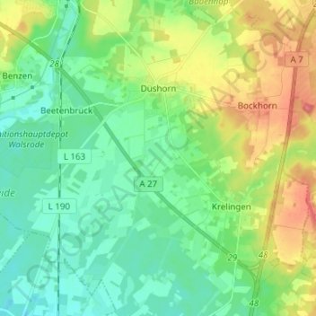
Name: Düshorn topographic map, elevation, terrain.
Location: Düshorn, Walsrode, Heidekreis, Niedersachsen, Deutschland (52.77733 9.56553 52.85229 9.66558)
Average elevation: 45 m
Minimum elevation: 22 m
Maximum elevation: 94 m
Make a donation
Gear up for your next adventure:
As an Amazon Associate, this site earns from qualifying purchases at no extra cost to you.
Other topographic maps
Click on a map to view its topography, its elevation and its terrain.
Make a donation
Gear up for your next adventure:
As an Amazon Associate, this site earns from qualifying purchases at no extra cost to you.
Make a donation
Gear up for your next adventure:
As an Amazon Associate, this site earns from qualifying purchases at no extra cost to you.