Geolocate

Falköping topographic map

Click on the map to display elevation.

About this map

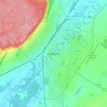
Name: Falköping topographic map, elevation, terrain.

Location: Falköping, Falköpings kommun, Västra Götaland County, Sweden (58.14525 13.52234 58.19384 13.58794)

Average elevation: 239 m

Minimum elevation: 199 m

Maximum elevation: 328 m

Other topographic maps

Click on a map to view its topography, its elevation and its terrain.

Bolstad

Sweden > Västra Götaland County

Average elevation: 55 m

Ljungskile

Sweden > Västra Götaland County

Average elevation: 53 m

Uddevalla

Sweden > Västra Götaland County

Average elevation: 71 m

Strömstad

Sweden > Västra Götaland County

Average elevation: 21 m

Ed

Sweden > Västra Götaland County

Average elevation: 155 m

Heestrand

Sweden > Västra Götaland County

Average elevation: 11 m

Trollhättan

Sweden > Västra Götaland County

Average elevation: 58 m

Mariestad

Sweden > Västra Götaland County

Average elevation: 59 m

Jonsered

Sweden > Västra Götaland County

Average elevation: 73 m

Henå

Sweden > Västra Götaland County

Average elevation: 158 m

Gear up for your next adventure:

💧Hydration Bladder - Hands-free hydration solution for long treks
🛏️Sleeping Bag - Warm and compact sleeping bags for outdoor camping
💧Reusable Water Bottle - Durable water bottles for hydration on trails
🧭GPS Tracker - Track your location in remote areas safely
🔦LED Headtorch - Bright and durable light for night activities

As an Amazon Associate, this site earns from qualifying purchases at no extra cost to you.