
Inverness County topographic map
Click on the map to display elevation.
About this map
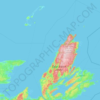
Name: Inverness County topographic map, elevation, terrain.
Location: Inverness County, Nova Scotia, Canada (45.60559 -61.60774 47.04586 -60.55626)
Average elevation: 71 m
Minimum elevation: -3 m
Maximum elevation: 531 m
Nova Scotia trails, hiking, mountain biking, running and outdoor activities
Other topographic maps
Click on a map to view its topography, its elevation and its terrain.
Mitchells Beach
Canada > Nova Scotia > Municipality of the County of Cumberland > West Pugwash
Average elevation: 7 m
Long Point Provincial Park
Canada > Nova Scotia > Municipality of the County of Inverness > Long Point
Average elevation: 32 m
Upper Kempt Head
Canada > Nova Scotia > Municipality of Victoria County > Kempt Head
Average elevation: 20 m
Westchester Valley
Canada > Nova Scotia > Municipality of the County of Cumberland
Average elevation: 194 m
Frasertown
Canada > Nova Scotia > Municipality of the County of Annapolis > Princedale
Average elevation: 138 m
Shingle Lake
Canada > Nova Scotia > Guysborough District Municipality > Forest Hill
Average elevation: 124 m
Sporting Mountain
Canada > Nova Scotia > Municipality of the County of Richmond > River Bourgeois
Average elevation: 59 m
Garrets Lake
Canada > Nova Scotia > Municipality of the County of Richmond > Salmon River
Average elevation: 48 m
Shunacadie
Canada > Nova Scotia > Cape Breton Regional Municipality > Shenacadie
Average elevation: 59 m
Nova Scotia peninsula
Canada > Nova Scotia > Hants County > Upper Rawdon
The Cobequid Mountains contain the highest elevation points on the peninsula. This low, heavily eroded part of the Appalachian Mountains, along with the Pictou-Antigonish Highlands, comprises a highland across the northern portion of the peninsula with average elevations between 250–300 metres. It was…
Average elevation: 118 m
Mersey River
Canada > Nova Scotia > Queens County > Kejimkujik National Park of Canada
Average elevation: 93 m
Annapolis Valley
Canada > Nova Scotia > Municipality of the County of Kings > Auburn
Average elevation: 77 m
Cape Split
Canada > Nova Scotia > Queens County > Kejimkujik National Park of Canada
Average elevation: 130 m
Chignecto Isthmus
Canada > Nova Scotia > Municipality of the County of Cumberland > Fort Lawrence
Average elevation: 14 m
River Philip Centre
Canada > Nova Scotia > Municipality of the County of Cumberland
Average elevation: 85 m
Starrs Point
Canada > Nova Scotia > Municipality of the County of Kings > Port Williams
Average elevation: 3 m
Gaspereau Mountain
Canada > Nova Scotia > Municipality of the County of Kings > Forest Hill
Average elevation: 185 m
White Hill
Canada > Nova Scotia > Cape Breton Highlands National Park > Cape Breton Highlands National Park
White Hill is a peak in the Cape Breton Highlands and is the highest elevation point in the province of Nova Scotia, Canada.
Average elevation: 488 m
Loon Lake Channel
Canada > Nova Scotia > Municipality of the County of Kings > Aylesford Lake
Average elevation: 220 m
Victoria Bridge
Canada > Nova Scotia > Cape Breton Regional Municipality > Upper Grand Mira
Average elevation: 17 m
Cameron Beach
Canada > Nova Scotia > Municipality of the County of Cumberland > Port Howe
Average elevation: 2 m
Eastern Shore District High School Park
Canada > Nova Scotia > Halifax County > Musquodoboit Harbour
Average elevation: 24 m