
Howden topographic map
Click on the map to display elevation.
About this map
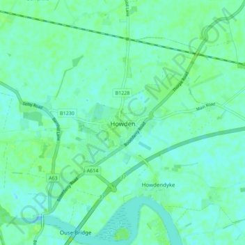
Name: Howden topographic map, elevation, terrain.
Location: Howden, East Riding of Yorkshire, England, United Kingdom (53.72232 -0.89837 53.77271 -0.84159)
Average elevation: 4 m
Minimum elevation: -3 m
Maximum elevation: 11 m
Other topographic maps
Click on a map to view its topography, its elevation and its terrain.
Little Driffield
United Kingdom > England > East Riding of Yorkshire > Driffield
Average elevation: 30 m
East Cottingwith
United Kingdom > England > East Riding of Yorkshire > East Cottingwith
Average elevation: 8 m
Malton Lane Plantation
United Kingdom > England > East Riding of Yorkshire > Bugthorpe
Average elevation: 54 m
Burton Constable Hall
United Kingdom > England > East Riding of Yorkshire > West Newton
Average elevation: 18 m
Willerby and Derringham Flood Alleviation Scheme
United Kingdom > England > East Riding of Yorkshire > Kirk Ella
Average elevation: 42 m