Geolocate

Heng County topographic map

Click on the map to display elevation.

About this map

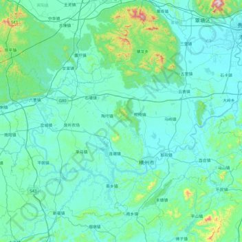
Name: Heng County topographic map, elevation, terrain.

Location: Heng County, Nanning, Guangxi, China (22.48712 108.79383 23.13701 109.61818)

Average elevation: 135 m

Minimum elevation: 37 m

Maximum elevation: 1,135 m

Other topographic maps

Click on a map to view its topography, its elevation and its terrain.

Gulan

China > Guangxi > Nanning

Average elevation: 225 m

Bolang

China > Guangxi > Nanning

Average elevation: 99 m

Tandun

China > Guangxi > Nanning

Average elevation: 124 m

Bahong

China > Guangxi > Nanning

Average elevation: 129 m

Kunlun

China > Guangxi > Nanning > Kunlun

Average elevation: 256 m

Gear up for your next adventure:

🥾Trail Running Boots - Durable shoes designed for trail running
🧳Compression Sacks - Maximize space in your backpack by shrinking gear
🧶550 Survival Paracord - Versatile utility cord for emergency repairs and rigging
🦯Trekking Poles - Reduced impact on joints for steep topographic climbs
🥾Trail Hiking Socks - Comfortable socks to prevent blisters and fatigue

As an Amazon Associate, this site earns from qualifying purchases at no extra cost to you.