Geolocate

Bereni topographic map

Click on the map to display elevation.

About this map

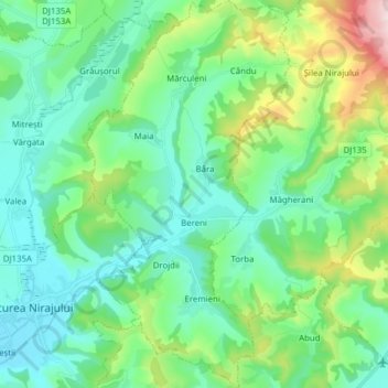
Name: Bereni topographic map, elevation, terrain.

Location: Bereni, Mureș, Romania (46.51186 24.82553 46.61835 24.90701)

Average elevation: 465 m

Minimum elevation: 341 m

Maximum elevation: 877 m

Other topographic maps

Click on a map to view its topography, its elevation and its terrain.

Eremieni

Romania > Mureș

Average elevation: 452 m

Transylvania

Romania > Mureș > Band

Average elevation: 648 m

Gear up for your next adventure:

🧥Waterproof Pants - Keep dry during rainy hiking conditions
🔭Compact Binoculars - Lightweight optics for scouting trails and wildlife
🧢Beanie Hat - Keep your head warm in cold weather
🧦Hiking Socks - Moisture-wicking and comfortable socks for long hikes
🥾Mountaineering Boots - Supportive boots for climbing and high-altitude hiking

As an Amazon Associate, this site earns from qualifying purchases at no extra cost to you.