Geolocate

Lunjen topographic map

Click on the map to display elevation.

About this map

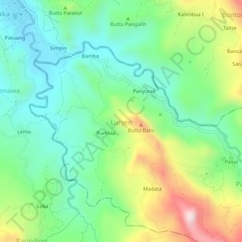
Name: Lunjen topographic map, elevation, terrain.

Location: Lunjen, Enrekang, South Sulawesi, Sulawesi, 91753, Indonesia (-3.44735 119.85466 -3.40735 119.89466)

Average elevation: 629 m

Minimum elevation: 451 m

Maximum elevation: 995 m

Other topographic maps

Click on a map to view its topography, its elevation and its terrain.

Baraka

Indonesia > South Sulawesi > Enrekang

Average elevation: 827 m

Bungin

Indonesia > South Sulawesi > Enrekang

Average elevation: 1,238 m

Buntu Batu

Indonesia > South Sulawesi > Enrekang

Average elevation: 1,459 m

Cendana

Indonesia > South Sulawesi > Enrekang

Average elevation: 152 m

Maiwa

Indonesia > South Sulawesi > Enrekang

Average elevation: 214 m

Malua

Indonesia > South Sulawesi > Enrekang

Average elevation: 709 m

Malua

Indonesia > South Sulawesi > Enrekang

Average elevation: 709 m

Alla

Indonesia > South Sulawesi > Enrekang

Average elevation: 1,037 m

Gear up for your next adventure:

🚲Bike Repair Kit - Essential tools for on-trail mechanical issues
🏕️Camping Hammock - Integrated protection for sleeping between trees
🧢Hiking Hat - Sun-protective and breathable hats for long treks
🧴Outdoor Sunscreen - High SPF protection for high-altitude UV exposure
👟Sport Hiking Sandals - Breathable footwear for water crossings and camp rest

As an Amazon Associate, this site earns from qualifying purchases at no extra cost to you.