Geolocate

Rampunan topographic map

Click on the map to display elevation.

About this map

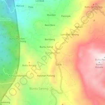
Name: Rampunan topographic map, elevation, terrain.

Location: Rampunan, Enrekang, South Sulawesi, Sulawesi, Indonesia (-3.34106 119.72961 -3.30106 119.76961)

Average elevation: 1,214 m

Minimum elevation: 685 m

Maximum elevation: 1,763 m

Other topographic maps

Click on a map to view its topography, its elevation and its terrain.

Malua

Indonesia > South Sulawesi > Enrekang

Average elevation: 709 m

Alla

Indonesia > South Sulawesi > Enrekang

Average elevation: 1,037 m

Baraka

Indonesia > South Sulawesi > Enrekang

Average elevation: 827 m

Bungin

Indonesia > South Sulawesi > Enrekang

Average elevation: 1,238 m

Cendana

Indonesia > South Sulawesi > Enrekang

Average elevation: 152 m

Maiwa

Indonesia > South Sulawesi > Enrekang

Average elevation: 214 m

Malua

Indonesia > South Sulawesi > Enrekang

Average elevation: 709 m

Buntu Batu

Indonesia > South Sulawesi > Enrekang

Average elevation: 1,459 m

Gear up for your next adventure:

🦟Insect Repellent - Keep mosquitoes and black flies away in wooded areas
🥾Approach Shoes - Shoes designed for climbing approaches and rugged trails
🧭GPS Outdoor Watch - Smart watch for navigation and fitness tracking in nature
🔦LED Headtorch - Bright and durable light for night activities
Family Camping Tent - Spacious tent suitable for family camping trips

As an Amazon Associate, this site earns from qualifying purchases at no extra cost to you.