Geolocate

Paladang topographic map

Click on the map to display elevation.

About this map

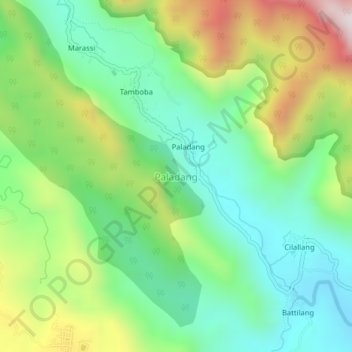
Name: Paladang topographic map, elevation, terrain.

Location: Paladang, Enrekang, South Sulawesi, Sulawesi, Indonesia (-3.66563 119.84750 -3.62563 119.88750)

Average elevation: 409 m

Minimum elevation: 142 m

Maximum elevation: 912 m

Other topographic maps

Click on a map to view its topography, its elevation and its terrain.

Malua

Indonesia > South Sulawesi > Enrekang

Average elevation: 709 m

Alla

Indonesia > South Sulawesi > Enrekang

Average elevation: 1,037 m

Baraka

Indonesia > South Sulawesi > Enrekang

Average elevation: 827 m

Bungin

Indonesia > South Sulawesi > Enrekang

Average elevation: 1,238 m

Cendana

Indonesia > South Sulawesi > Enrekang

Average elevation: 152 m

Maiwa

Indonesia > South Sulawesi > Enrekang

Average elevation: 214 m

Malua

Indonesia > South Sulawesi > Enrekang

Average elevation: 709 m

Buntu Batu

Indonesia > South Sulawesi > Enrekang

Average elevation: 1,459 m

Gear up for your next adventure:

🧥Softshell Jacket - Windproof and breathable jacket for hiking
🚲Heavy Duty Bike Lock - Secure your bike at the trailhead or during stops
🥾Lightweight Hiking Boots - Boots for comfort and mobility on long hikes
💧Filtered Water Bottle - Safe drinking water on the go
🥾Waterproof Trail Shoes - Shoes designed to handle wet terrain

As an Amazon Associate, this site earns from qualifying purchases at no extra cost to you.