
Jarvie topographic map
Interactive map
Click on the map to display elevation.
About this map
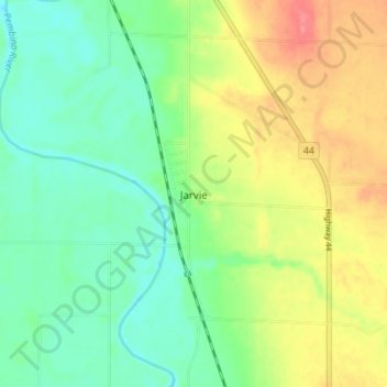
Name: Jarvie topographic map, elevation, terrain.
Location: Jarvie, Westlock County, Alberta, Canada (54.43576 -114.00698 54.47576 -113.96698)
Average elevation: 625 m
Minimum elevation: 596 m
Maximum elevation: 671 m
Other topographic maps
Click on a map to view its topography, its elevation and its terrain.
Halfway Lake
Canada > Alberta > Westlock County
Halfway Lake, Westlock County, Alberta, Canada
Average elevation: 631 m
Nestow
Canada > Alberta > Westlock County
Nestow, Westlock County, Alberta, Canada
Average elevation: 634 m