Geolocate

Nottwil topographic map

Click on the map to display elevation.

About this map

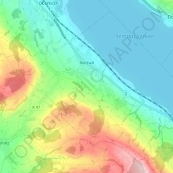
Name: Nottwil topographic map, elevation, terrain.

Location: Nottwil, Lucerne, 6207, Switzerland (47.10836 8.10167 47.15315 8.17750)

Average elevation: 590 m

Minimum elevation: 500 m

Maximum elevation: 791 m

Other topographic maps

Click on a map to view its topography, its elevation and its terrain.

Hämikon

Switzerland > Lucerne

Average elevation: 671 m

Alpach

Switzerland > Lucerne > Escholzmatt-Marbach > Escholzmatt

Average elevation: 966 m

Hellbühl

Switzerland > Lucerne

Average elevation: 639 m

Gunzwil

Switzerland > Lucerne

Average elevation: 671 m

Schiltalp

Switzerland > Lucerne > Kriens

Average elevation: 962 m

Allmendhubel

Switzerland > Lucerne > Menznau

Average elevation: 636 m

Schloss Meggenhorn

Switzerland > Lucerne > Meggen

Average elevation: 450 m

Sörenberg

Switzerland > Lucerne

Average elevation: 1,386 m

Marbachegg

Switzerland > Lucerne > Escholzmatt-Marbach

Average elevation: 1,159 m

Schachen

Switzerland > Lucerne > Werthenstein > Schachen

Average elevation: 671 m

Gear up for your next adventure:

🧥Thermal Fleece Jacket - Versatile insulation for changing mountain temperatures
📷Outdoor Action Camera - Capture high-elevation views and rugged adventures
🧢Hiking Hat - Sun-protective and breathable hats for long treks
🥾All-Terrain Hiking Boots - Versatile boots for varied hiking conditions
🧴Sunscreen SPF - Broad-spectrum sunscreen for outdoor activities

As an Amazon Associate, this site earns from qualifying purchases at no extra cost to you.