Geolocate

Sparkbrook topographic map

Click on the map to display elevation.

About this map
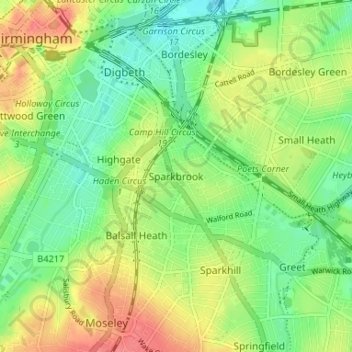
Name: Sparkbrook topographic map, elevation, terrain.

Location: Sparkbrook, Birmingham, West Midlands, England, B11 1AG, United Kingdom (52.44397 -1.89583 52.48397 -1.85583)

Average elevation: 124 m

Minimum elevation: 98 m

Maximum elevation: 159 m

Other topographic maps

Click on a map to view its topography, its elevation and its terrain.
Sutton Coldfield

United Kingdom > England > Birmingham

Average elevation: 124 m

Sutton Park

United Kingdom > England > Birmingham > Four Oaks

Average elevation: 145 m

Lifford Reservoir

United Kingdom > England > Birmingham > Lifford

Average elevation: 150 m

Highbury Park

United Kingdom > England > Birmingham > Kings Heath

Average elevation: 142 m

Pype Hayes

United Kingdom > England > Birmingham > Tyburn

Average elevation: 104 m

North Edgbaston

United Kingdom > England > Birmingham

Average elevation: 162 m

Joy's Wood

United Kingdom > England > Birmingham > Wake Green

Average elevation: 140 m

Calthorpe Park

United Kingdom > England > Birmingham > Highgate

Average elevation: 128 m

Sutton Coldfield

United Kingdom > England > Birmingham

Average elevation: 124 m

Sutton Park

United Kingdom > England > Birmingham > Four Oaks

Average elevation: 145 m

Gear up for your next adventure:

🥤Collapsible Travel Cup - Saves space and weight in your mess kit
👟Leg Gaiters - Keep debris, mud, and snow out of your boots
🥾All-Terrain Hiking Boots - Versatile boots for varied hiking conditions
🧼Biodegradable Camp Soap - Environmentally friendly cleaning for gear and body
🌡️Emergency Mylar Blankets - Compact thermal protection for unexpected nights outdoors

As an Amazon Associate, this site earns from qualifying purchases at no extra cost to you.