
Springhill Plantation topographic map
Click on the map to display elevation.
About this map
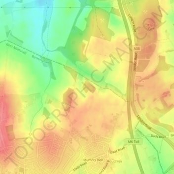
Name: Springhill Plantation topographic map, elevation, terrain.
Average elevation: 146 m
Minimum elevation: 103 m
Maximum elevation: 176 m
Other topographic maps
Click on a map to view its topography, its elevation and its terrain.
Banners Gate
United Kingdom > England > Birmingham > Sutton Coldfield > New Oscott
Average elevation: 144 m
Roughley
United Kingdom > England > Birmingham > Sutton Coldfield > Little Sutton
Average elevation: 139 m
Walmley Ash
United Kingdom > England > Birmingham > Sutton Coldfield > Minworth
Average elevation: 99 m
Minworth Greaves
United Kingdom > England > Birmingham > Sutton Coldfield > Minworth
Average elevation: 90 m
Minworth Greaves
United Kingdom > England > Birmingham > Sutton Coldfield > Minworth
Average elevation: 90 m
Walmley Ash
United Kingdom > England > Birmingham > Sutton Coldfield > Minworth
Average elevation: 99 m