Geolocate

Castelluccio topographic map

Click on the map to display elevation.

About this map

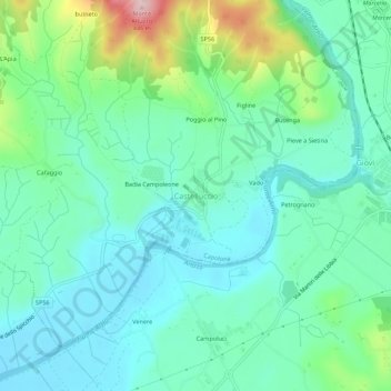
Name: Castelluccio topographic map, elevation, terrain.

Location: Castelluccio, Capolona, Arezzo, Tuscany, Italy (43.50523 11.81511 43.54523 11.85511)

Average elevation: 260 m

Minimum elevation: 202 m

Maximum elevation: 442 m

Other topographic maps

Click on a map to view its topography, its elevation and its terrain.

Castiglion Fiorentino

Italy > Tuscany > Arezzo

Average elevation: 374 m

Loro Ciuffenna

Italy > Tuscany > Arezzo

Average elevation: 602 m

Toppole

Italy > Tuscany > Arezzo > Anghiari

Average elevation: 509 m

Pratovecchio Stia

Italy > Tuscany > Arezzo

Average elevation: 856 m

Pergine Valdarno

Italy > Tuscany > Arezzo

Average elevation: 313 m

Cavriglia

Italy > Tuscany > Arezzo

Average elevation: 314 m

Chitignano

Italy > Tuscany > Arezzo

Average elevation: 655 m

Lucignano

Italy > Tuscany > Arezzo > Lucignano

Average elevation: 301 m

Gear up for your next adventure:

🧦Hiking Socks - Moisture-wicking and comfortable socks for long hikes
👟Leg Gaiters - Keep debris, mud, and snow out of your boots
🕶️Polarized Sunglasses - Protect your eyes with durable polarized lenses
🥤Collapsible Travel Cup - Saves space and weight in your mess kit
🕶️Polarized Sunglasses - Reduces glare from snow and water at high elevations

As an Amazon Associate, this site earns from qualifying purchases at no extra cost to you.