Geolocate

Lucignano topographic map

Click on the map to display elevation.

About this map

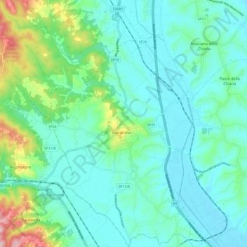
Name: Lucignano topographic map, elevation, terrain.

Location: Lucignano, Arezzo, Tuscany, 52046, Italy (43.23357 11.66164 43.32145 11.78132)

Average elevation: 301 m

Minimum elevation: 246 m

Maximum elevation: 523 m

Other topographic maps

Click on a map to view its topography, its elevation and its terrain.

Santa Maria

Italy > Tuscany > Arezzo > Lucignano > Santa Maria

Average elevation: 298 m

Gear up for your next adventure:

🌡️Emergency Mylar Blankets - Compact thermal protection for unexpected nights outdoors
Family Camping Tent - Spacious tent suitable for family camping trips
🔭Compact Monocular - One-handed bird watching and trail spotting
🛌Down Sleeping Bag - Superior warmth-to-weight ratio for cold nights
💡Portable Camping Lamp - Rechargeable lamp for campsite lighting

As an Amazon Associate, this site earns from qualifying purchases at no extra cost to you.