Geolocate

Antrodoco topographic map

Click on the map to display elevation.

About this map

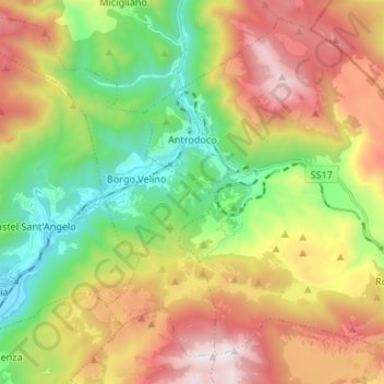
Name: Antrodoco topographic map, elevation, terrain.

Location: Antrodoco, Rieti, Lazio, 02013, Italy (42.35797 13.06194 42.44726 13.19508)

Average elevation: 1,041 m

Minimum elevation: 412 m

Maximum elevation: 1,885 m

Other topographic maps

Click on a map to view its topography, its elevation and its terrain.

Monticchio

Italy > Lazio > Rieti > Monte San Giovanni in Sabina

Average elevation: 778 m

Poggio Corese

Italy > Lazio > Rieti

Average elevation: 353 m

Villanova

Italy > Lazio > Rieti > Accumoli

Average elevation: 1,041 m

Pian de' Valli

Italy > Lazio > Rieti > Rieti > Pian de' Valli

Average elevation: 1,529 m

Gear up for your next adventure:

🥾Mountain Hiking Boots - High-traction boots for rocky terrain
🧼Biodegradable Camp Soap - Environmentally friendly cleaning for gear and body
🚲Handlebar Phone Mount - View topographic-map.com live while cycling
🥾Trekking Poles - Adjustable trekking poles to reduce knee stress and improve stability
💡Portable Camping Lamp - Rechargeable lamp for campsite lighting

As an Amazon Associate, this site earns from qualifying purchases at no extra cost to you.