
Make a donation
Gear up for your next adventure:
As an Amazon Associate, this site earns from qualifying purchases at no extra cost to you.
Folly Creek topographic map
Click on the map to display elevation.
Make a donation
Gear up for your next adventure:
As an Amazon Associate, this site earns from qualifying purchases at no extra cost to you.
About this map
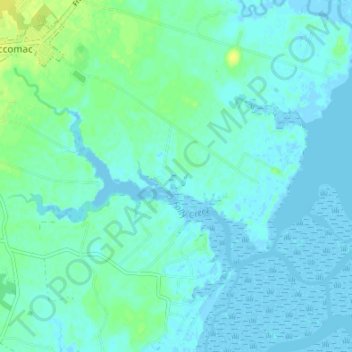
Name: Folly Creek topographic map, elevation, terrain.
Location: Folly Creek, Accomack County, Virginia, United States (37.68394 -75.66491 37.71657 -75.59740)
Average elevation: 4 m
Minimum elevation: -5 m
Maximum elevation: 15 m
Make a donation
Gear up for your next adventure:
As an Amazon Associate, this site earns from qualifying purchases at no extra cost to you.
Other topographic maps
Click on a map to view its topography, its elevation and its terrain.
Wattsville
United States > Virginia > Accomack County
It lies at an elevation of 3 feet.
Average elevation: 11 m
Make a donation
Gear up for your next adventure:
As an Amazon Associate, this site earns from qualifying purchases at no extra cost to you.
Painter
United States > Virginia > Accomack County
It lies at an elevation of 36 feet.
Average elevation: 10 m
Deep Creek
United States > Virginia > Accomack County
It lies at an elevation of 3 feet.
Average elevation: 1 m
Make a donation
Gear up for your next adventure:
As an Amazon Associate, this site earns from qualifying purchases at no extra cost to you.
Quinby
United States > Virginia > Accomack County
It lies at an elevation of 7 feet.
Average elevation: 1 m
Make a donation
Gear up for your next adventure:
As an Amazon Associate, this site earns from qualifying purchases at no extra cost to you.