Geolocate

Boston topographic map

Click on the map to display elevation.

About this map

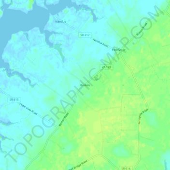
Name: Boston topographic map, elevation, terrain.

Location: Boston, Accomack County, Virginia, 23420, United States (37.58930 -75.86271 37.62930 -75.82271)

Average elevation: 6 m

Minimum elevation: -2 m

Maximum elevation: 14 m

Other topographic maps

Click on a map to view its topography, its elevation and its terrain.

Painter

United States > Virginia > Accomack County

It lies at an elevation of 36 feet.

Average elevation: 10 m

Gear up for your next adventure:

🥘Camping Cookware Set - Compact nesting pots and pans for trail cooking
🔋Lithium AA Batteries - Long-lasting power that performs in extreme cold
🔦LED Flashlight - Powerful and long-lasting flashlight for camping and emergencies
🌡️Emergency Mylar Blankets - Compact thermal protection for unexpected nights outdoors
🛶Kayak Accessories - Essential gear for safe and fun kayaking adventures

As an Amazon Associate, this site earns from qualifying purchases at no extra cost to you.