
Shields topographic map
Click on the map to display elevation.
About this map
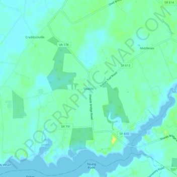
Name: Shields topographic map, elevation, terrain.
Location: Shields, Accomack County, Virginia, 23306, United States (37.55013 -75.87354 37.59013 -75.83354)
Average elevation: 6 m
Minimum elevation: -5 m
Maximum elevation: 22 m
Other topographic maps
Click on a map to view its topography, its elevation and its terrain.
Painter
United States > Virginia > Accomack County
It lies at an elevation of 36 feet.
Average elevation: 10 m