
Indian Rocks Beach topographic map
Click on the map to display elevation.
About this map
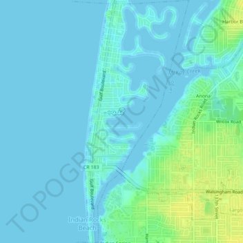
Name: Indian Rocks Beach topographic map, elevation, terrain.
Location: Indian Rocks Beach, Pinellas County, Florida, United States (27.87229 -82.85149 27.91030 -82.83323)
Average elevation: 4 m
Minimum elevation: -3 m
Maximum elevation: 19 m
Other topographic maps
Click on a map to view its topography, its elevation and its terrain.
Lealman
United States > Florida > Pinellas County
Lealman is located at 27°49′10″N 82°41′4″W / 27.81944°N 82.68444°W / 27.81944; -82.68444 (27.8197, -82.6846). The community is bordered by the city of Pinellas Park to the north, St. Petersburg to the east and south, and by the town of West Lealman to the west. The elevation is 49 feet (15…
Average elevation: 13 m
Boca Ciega
United States > Florida > Pinellas County > Treasure Island > Boca Ciega
Average elevation: 1 m
Saint George Lake
United States > Florida > Pinellas County > Palm Harbor > Saint George
Average elevation: 12 m