Geolocate

Noville topographic map

Click on the map to display elevation.

About this map

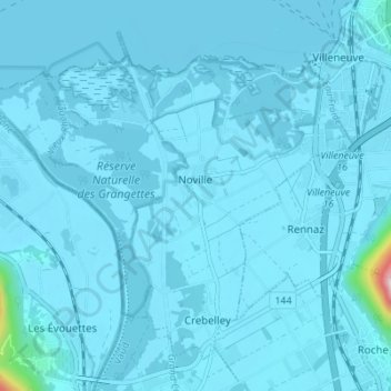
Name: Noville topographic map, elevation, terrain.

Location: Noville, District d'Aigle, Vaud, 1845, Switzerland (46.35986 6.85882 46.39981 6.92750)

Average elevation: 384 m

Minimum elevation: 369 m

Maximum elevation: 884 m

Other topographic maps

Click on a map to view its topography, its elevation and its terrain.

Villars-sur-Ollon

Switzerland > Vaud > District d'Aigle

Average elevation: 1,293 m

Les Diablerets

Switzerland > Vaud > District d'Aigle > Ormont-Dessus

Average elevation: 1,453 m

Chesières

Switzerland > Vaud > District d'Aigle

Average elevation: 1,247 m

Les Posses-sur-Bex

Switzerland > Vaud > District d'Aigle

Average elevation: 896 m

Les Ecovets

Switzerland > Vaud > District d'Aigle > Huémoz

Average elevation: 1,091 m

Les Mosses

Switzerland > Vaud > District d'Aigle > Ormont-Dessous

Average elevation: 1,634 m

Morcles

Switzerland > Vaud > District d'Aigle > Lavey-Morcles

Average elevation: 1,139 m

Drapel

Switzerland > Vaud > District d'Aigle > Aigle

Average elevation: 716 m

Vallée du Rhône

Switzerland > Vaud > District d'Aigle

Average elevation: 1,378 m

Chambon

Switzerland > Vaud > District d'Aigle > Roche (VD)

Average elevation: 485 m

Glacier du Dar

Switzerland > Vaud > District d'Aigle > Ormont-Dessus

Average elevation: 2,554 m

Gear up for your next adventure:

🛶Canoe Life Vest - Safety vest for water sports
Camping Groundsheet - Protect your tent from moisture and dirt
💧Reusable Water Bottle - Durable water bottles for hydration on trails
🧭GPS Handheld Device - Reliable GPS navigation for outdoor adventures
🧼Biodegradable Camp Soap - Environmentally friendly cleaning for gear and body

As an Amazon Associate, this site earns from qualifying purchases at no extra cost to you.