
Make a donation
Gear up for your next adventure:
As an Amazon Associate, this site earns from qualifying purchases at no extra cost to you.
Ona topographic map
Click on the map to display elevation.
Make a donation
Gear up for your next adventure:
As an Amazon Associate, this site earns from qualifying purchases at no extra cost to you.
About this map
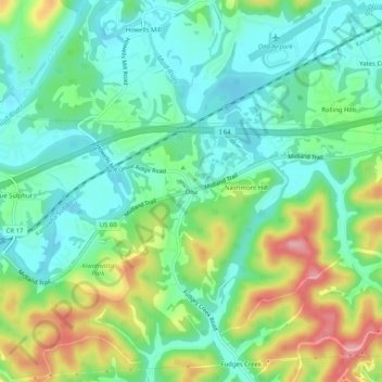
Name: Ona topographic map, elevation, terrain.
Location: Ona, Cabell County, West Virginia, 25545, United States (38.40481 -82.23320 38.44481 -82.19320)
Average elevation: 207 m
Minimum elevation: 163 m
Maximum elevation: 300 m
Make a donation
Gear up for your next adventure:
As an Amazon Associate, this site earns from qualifying purchases at no extra cost to you.
Other topographic maps
Click on a map to view its topography, its elevation and its terrain.
Huntington
United States > West Virginia > Cabell County
Huntington is located in the southwestern corner of West Virginia, on the border with Ohio, on the southern bank of the Ohio River, at the confluence with the Guyandotte River. The city lies at 38°25′9.30″N 82°26′42.55″W / 38.4192500°N 82.4451528°W / 38.4192500; -82.4451528 (38.4192496,…
Average elevation: 218 m
Huntington
United States > West Virginia > Cabell County
Huntington is located in western Cabell County at 38°25′9.30″N 82°26′42.55″W / 38.4192500°N 82.4451528°W / 38.4192500; -82.4451528 (38.4192496, -82.4451540). The elevation is 564 feet (172 m) above sea level.
Average elevation: 218 m
Make a donation
Gear up for your next adventure:
As an Amazon Associate, this site earns from qualifying purchases at no extra cost to you.
Huntington
United States > West Virginia > Cabell County
Huntington is located in the southwestern corner of West Virginia, on the border with Ohio, on the southern bank of the Ohio River, at the confluence with the Guyandotte River. The city lies at 38°25′9.30″N 82°26′42.55″W / 38.4192500°N 82.4451528°W / 38.4192500; -82.4451528 (38.4192496,…
Average elevation: 218 m
Make a donation
Gear up for your next adventure:
As an Amazon Associate, this site earns from qualifying purchases at no extra cost to you.
Huntington
United States > West Virginia > Cabell County
Huntington is located in western Cabell County at 38°25′9.30″N 82°26′42.55″W / 38.4192500°N 82.4451528°W / 38.4192500; -82.4451528 (38.4192496, -82.4451540). The elevation is 564 feet (172 m) above sea level.
Average elevation: 218 m