
Make a donation
Gear up for your next adventure:
As an Amazon Associate, this site earns from qualifying purchases at no extra cost to you.
Huntington topographic map
Click on the map to display elevation.
Make a donation
Gear up for your next adventure:
As an Amazon Associate, this site earns from qualifying purchases at no extra cost to you.
Huntington
Huntington is located in the southwestern corner of West Virginia, on the border with Ohio, on the southern bank of the Ohio River, at the confluence with the Guyandotte River. The city lies at 38°25′9.30″N 82°26′42.55″W / 38.4192500°N 82.4451528°W / 38.4192500; -82.4451528 (38.4192496, -82.4451540), with an elevation of 564 feet (172 m) above sea level. According to the United States Census Bureau, the city has an area of 18.461 square miles (47.81 km2), of which 16.219 square miles (42.01 km2) is land and 2.242 square miles (5.81 km2) is water. The Guyandotte River joins the Ohio River about 5 miles (8.0 km) east of downtown. Huntington fills the roughly three-mile wide flood plain of the south bank of the Ohio River for eighty square blocks and portions of the hills to the immediate south and southeast.
Make a donation
Gear up for your next adventure:
As an Amazon Associate, this site earns from qualifying purchases at no extra cost to you.
About this map
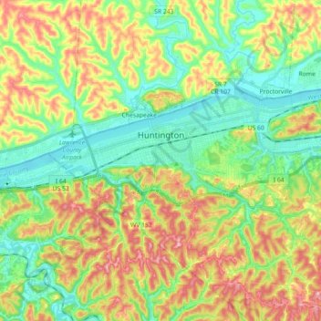
Name: Huntington topographic map, elevation, terrain.
Location: Huntington, Cabell County, West Virginia, United States (38.37599 -82.53179 38.43970 -82.35319)
Average elevation: 218 m
Minimum elevation: 156 m
Maximum elevation: 314 m
Make a donation
Gear up for your next adventure:
As an Amazon Associate, this site earns from qualifying purchases at no extra cost to you.
Other topographic maps
Click on a map to view its topography, its elevation and its terrain.