
Make a donation
Gear up for your next adventure:
As an Amazon Associate, this site earns from qualifying purchases at no extra cost to you.
Huntington topographic map
Click on the map to display elevation.
Make a donation
Gear up for your next adventure:
As an Amazon Associate, this site earns from qualifying purchases at no extra cost to you.
Huntington
Huntington is located in western Cabell County at 38°25′9.30″N 82°26′42.55″W / 38.4192500°N 82.4451528°W / 38.4192500; -82.4451528 (38.4192496, -82.4451540). The elevation is 564 feet (172 m) above sea level.
Make a donation
Gear up for your next adventure:
As an Amazon Associate, this site earns from qualifying purchases at no extra cost to you.
About this map
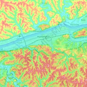
Name: Huntington topographic map, elevation, terrain.
Location: Huntington, Cabell County, West Virginia, United States (38.37599 -82.53179 38.43970 -82.35319)
Average elevation: 218 m
Minimum elevation: 156 m
Maximum elevation: 314 m
Make a donation
Gear up for your next adventure:
As an Amazon Associate, this site earns from qualifying purchases at no extra cost to you.
Other topographic maps
Click on a map to view its topography, its elevation and its terrain.