Geolocate

Acton topographic map

Click on the map to display elevation.

About this map
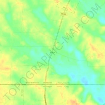
Name: Acton topographic map, elevation, terrain.

Location: Acton, McNairy County, West Tennessee, Tennessee, 38357, United States (34.98814 -88.47949 35.02814 -88.43949)

Average elevation: 146 m

Minimum elevation: 128 m

Maximum elevation: 163 m

Other topographic maps

Click on a map to view its topography, its elevation and its terrain.
Selmer

United States > Tennessee > McNairy County

Average elevation: 152 m

Michie

United States > Tennessee > McNairy County

Average elevation: 150 m

Stantonville

United States > Tennessee > McNairy County

Average elevation: 144 m

Michie

United States > Tennessee > McNairy County

Average elevation: 150 m

Finger

United States > Tennessee > McNairy County

Average elevation: 143 m

Ramer

United States > Tennessee > McNairy County > Ramer

Average elevation: 132 m

Gear up for your next adventure:

🛶Waterproof Dry Bags - Keep electronics and clothes dry during river crossings
🧥Packable Rain Jacket - Breathable waterproof layer for unpredictable weather
💧Hydration Bladder - Hands-free hydration solution for long treks
🛌Insulated Sleeping Pad - Critical thermal barrier between you and the cold ground
💡Portable Camping Lamp - Rechargeable lamp for campsite lighting

As an Amazon Associate, this site earns from qualifying purchases at no extra cost to you.