
ولسوالی ورسج topographic map
Interactive map
Click on the map to display elevation.
About this map
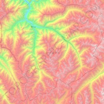
Name: ولسوالی ورسج topographic map, elevation, terrain.
Location: ولسوالی ورسج, Wilaya Tachar, Afghanistan (35.78272 69.76583 36.32931 70.49268)
Average elevation: 3,935 m
Minimum elevation: 1,548 m
Maximum elevation: 5,979 m
Other topographic maps
Click on a map to view its topography, its elevation and its terrain.
ولسوالی اشکمش
ولسوالی اشکمش, Wilaya Tachar, Afghanistan
Average elevation: 1,693 m
ولسوالی چاهآب
ولسوالی چاهآب, Wilaya Tachar, Afghanistan
Average elevation: 1,269 m