
ولسوالی اشکمش topographic map
Interactive map
Click on the map to display elevation.
About this map
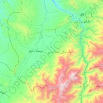
Name: ولسوالی اشکمش topographic map, elevation, terrain.
Location: ولسوالی اشکمش, Wilaya Tachar, Afghanistan (36.22818 69.17553 36.53573 69.67298)
Average elevation: 1,693 m
Minimum elevation: 805 m
Maximum elevation: 4,277 m
Other topographic maps
Click on a map to view its topography, its elevation and its terrain.
ولسوالی چاهآب
ولسوالی چاهآب, Wilaya Tachar, Afghanistan
Average elevation: 1,269 m
ولسوالی ورسج
ولسوالی ورسج, Wilaya Tachar, Afghanistan
Average elevation: 3,935 m