Geolocate

LaFayette topographic map

Click on the map to display elevation.

About this map

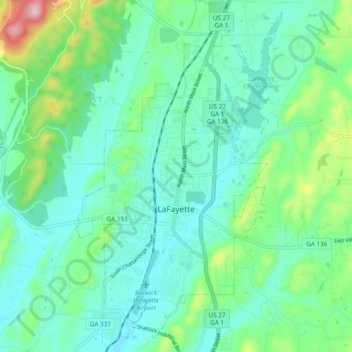
Name: LaFayette topographic map, elevation, terrain.

Location: LaFayette, Walker County, Georgia, United States (34.67274 -85.30921 34.75133 -85.25308)

Average elevation: 276 m

Minimum elevation: 224 m

Maximum elevation: 455 m

Other topographic maps

Click on a map to view its topography, its elevation and its terrain.

Catlett

United States > Georgia > Walker County

Average elevation: 287 m

Villanow

United States > Georgia > Walker County

Average elevation: 282 m

Blowing Spring

United States > Georgia > Walker County

Average elevation: 324 m

White Oak

United States > Georgia > Walker County

Average elevation: 249 m

Gear up for your next adventure:

Tent Footprint - Protect tent floor and increase durability
🥾Waterproof Hiking Boots - Boots keeping your feet dry in wet conditions
🧤Insulated Winter Gloves - Heavy-duty protection for sub-zero Canadian adventures
🧢Hiking Hat - Sun-protective and breathable hats for long treks
Bushcraft Tarp - Versatile emergency shelter or gear protection

As an Amazon Associate, this site earns from qualifying purchases at no extra cost to you.