Geolocate

Appalachian topographic map

Click on the map to display elevation.

About this map

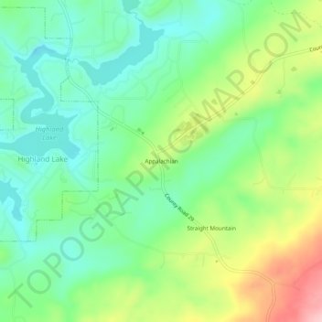
Name: Appalachian topographic map, elevation, terrain.

Location: Appalachian, Blount County, Alabama, United States (33.86482 -86.42193 33.90482 -86.38193)

Average elevation: 324 m

Minimum elevation: 262 m

Maximum elevation: 443 m

Other topographic maps

Click on a map to view its topography, its elevation and its terrain.

Blountsville

United States > Alabama > Blount County

Average elevation: 247 m

Susan Moore

United States > Alabama > Blount County

Average elevation: 245 m

Nectar

United States > Alabama > Blount County

Average elevation: 178 m

Hayden

United States > Alabama > Blount County

Average elevation: 180 m

Oneonta

United States > Alabama > Blount County

Average elevation: 277 m

Locust Fork

United States > Alabama > Blount County

Average elevation: 186 m

Oneonta

United States > Alabama > Blount County

Average elevation: 278 m

Hayden

United States > Alabama > Blount County

Average elevation: 180 m

Snead

United States > Alabama > Blount County

Average elevation: 238 m

Rosa

United States > Alabama > Blount County

Average elevation: 234 m

Hayden

United States > Alabama > Blount County

Average elevation: 180 m

Gear up for your next adventure:

🧤Insulated Winter Gloves - Heavy-duty protection for sub-zero Canadian adventures
🧊Insulated Water Bottle - Keeps drinks cold in summer and prevents freezing in winter
🥾Waterproof Hiking Shoes - Durable shoes for wet and rugged trails
🧢Outdoor Cap - Protective cap for sun and rain during hikes
🔨Vehicle Emergency Tool - Safety tool for remote road trips to trailheads

As an Amazon Associate, this site earns from qualifying purchases at no extra cost to you.