Geolocate

Oneonta topographic map

Click on the map to display elevation.

About this map

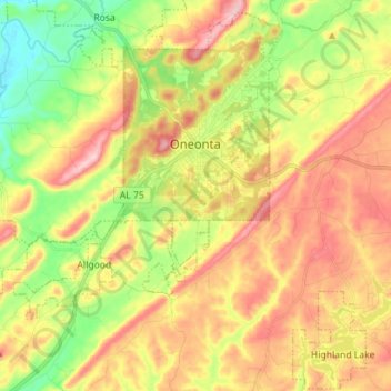
Name: Oneonta topographic map, elevation, terrain.

Location: Oneonta, Blount County, Alabama, 35121, United States (33.87801 -86.58282 33.98732 -86.44190)

Average elevation: 278 m

Minimum elevation: 160 m

Maximum elevation: 402 m

Other topographic maps

Click on a map to view its topography, its elevation and its terrain.

Summit

United States > Alabama > Blount County

Average elevation: 260 m

Royal

United States > Alabama > Blount County

Average elevation: 234 m

Woodhaven

United States > Alabama > Blount County

Average elevation: 255 m

Appalachian

United States > Alabama > Blount County

Average elevation: 324 m

Raccoon Mountain

United States > Alabama > Blount County

Average elevation: 326 m

Appalachian

United States > Alabama > Blount County

Average elevation: 324 m

Appalachian

United States > Alabama > Blount County

Average elevation: 324 m

Sulpher Springs

United States > Alabama > Blount County

Average elevation: 129 m

Nyota

United States > Alabama > Blount County

Average elevation: 142 m

Snead

United States > Alabama > Blount County

Average elevation: 238 m

Gear up for your next adventure:

🧥Waterproof Jacket - Lightweight rain jackets for hiking and outdoor activities
🧣Merino Neck Gaiter - Protects against wind, sun, and cold at high altitudes
🧦Outdoor Socks - Durable socks designed for hiking and outdoor sports
Lightweight Backpacking Tent - Compact tent for efficient hiking trips
🥾Mountaineering Boots - Supportive boots for climbing and high-altitude hiking

As an Amazon Associate, this site earns from qualifying purchases at no extra cost to you.